Orbiting Carbon Observatory-3OCO-3
Calibration is a critical step for all remote sensing data. Calibration ensures that the data received from the space borne instrument, such as OCO-3 on the International Space Station (ISS), will be converted into meaningful and accurate measurements. This step also ensures that the available data will be correct and reliable for those who want to use it.
To accurately retrieve the O2 and CO2 concentrations, it is necessary to know:
Ongoing calibration exercises during the space operations of OCO-3 will ensure that the mission obtains relatively bias-free radiance measurements. Accurate radiance measures are crucial to retrieve XCO2, or the amount of CO2 in the measured space, with the precision needed to determine the geographic distribution of CO2sources and sinks. This aspect of the OCO-2 mission is vital as CO2 sources and sinks must be inferred from small (<2%) spatial variations in XCO2. OCO-2 will have a precision of <0.3% (1 ppm), allowing for the quantification of CO2 sources and sinks.
The OCO-3 instrument focal planes will record the “brightness” of the incident spectral radiances as raw data numbers (DN). Data numbers are measures without units. For the OCO-3 mission, data numbers that represent spectral radiances range from 0 to 65535. Then, the data numbers are converted into wavelength-dependent measurements that are expressed into physical units of photons per square meter per steradian per micron per second through radiometric calibration.
Radiometric calibration is the process that collects and applies the parameters needed to convert the instrument output into physical measures. The radiance measure generated by the calibration process are the critical component of the OCO-3 Level 1B Product. A dedicated team oversees the radiometric calibration process for the entire OCO-3 mission. This team maintains the algorithms and updates the parameters required to generate accurate radiances.
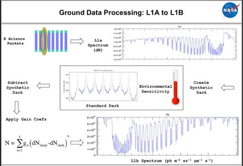
Ground Data Processing: L1A to L1B
Variable intensity light source (radiometric)In addition, detail laboratory ground tests have been performed pre-launch including:
The calibration team has characterized the instrument on the ground before launch and the characterization exercise will yield the initial set of parameters required to convert instrument data numbers into incident radiances. Once the instrument is in flight, some calibrations can be maintained and it will be critical to track changes with time. The trackable calibrations are: